Geography
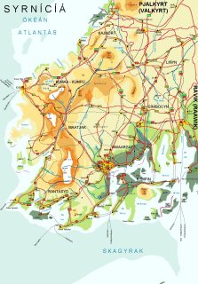
Surnichia is located on the Scandinavian peninsula, in Northern Europe. It is about 161.000 square kilometres in size, and both the longest north-south and the longest east-west distance are about 500 km. Surnichia has a varied landscape. In the west, it is characterized by rugged, mountainous areas dissected by deep fjords along the Atlantic coast. The eastern parts of the country consist of forested hills. The mountains are part of the Scandinavian highlands, of which the highest peaks are located on Surnichian ground: mount Akkló in Kúmaa-Kúmpú is the highest, with 3480 m. It is followed by Hestóníá (2925 m), Dervon (2520 m) and Monteg Kzair (Black Mountain; 2226 m). Large mountain plateaus, the 'fjels', can also be found here. The most well-known fjel is the Dovrřfjel, which is home to a large population of reindeer.
On the island Rympin, in the southeast of Surnichia, the Rympin mountain rises up from the sea. It was thought to be an extinct volcano until 2076, when an explosive eruption accompanied by a heavy earthquake caused a large area, now known as the Rympin island, to be ripped off from the mainland. In addition, magma from the volcano landing in the sea created several new islands in the Skagerrak. The Rympin volcano has to date shown no signs of an imminent new eruption. Today, Surnichia has seventeen large islands (over 30 km2) and thousands of smaller ones.
Surnichia is also rich in water masses. First of all, numerous fjords can be found all along Surnichia's coast, but mainly in the western part of the country, where they cut through the mountain range. The fjords can reach up to tens of kilometres inland. It is also in this area where many glaciers can be found. Meltwater from these glaciers comes together in mountain lakes such as Gýralák and Lágýnálák. In addition, many rivers and streams flow down from the mountains and cut through the landscape. The Grýná river is the longest (458 km) in Surnichia, but springs in Valkurt and mouths into the Isláfjort, Raawik. In the north, most rivers mouth into the Atlantic Ocean, in the west they mouth into the North Sea, in the south into the Skagerrak, and in the southeast into one of the several smaller seas surrounding the Rympin island.
